2018-2019
LoRAP Sub-project
“Testing the Archaeological Potentialities of Khok Puthsa site”
Khok Phutsa site (N 14°49’31”; E 100°37’54”; Tambon Thanon Yai, Lopburi Capital District) is located at ca. 1 km from the Thanon Yai moated site and ca. 2,5 km from Tha Kae moated site. The area we excavated, judging from the aerial photograph taken in 1945 and from 2004 and 2020 satellite images (courtesy Google Earth Pro), is located immediately outside the southern side of a moated site today entirely covered by residential housing substantially part of the Lopburi urban sprawl zone. The three sites (Tha Kae, Thanon Yai and Khok Phutsa) aligned on a Northwest-Southeast axis, as far as can be seen from the aerial images, occupy a terrace of the same system of paleo-channels (Fig.s 1-3).
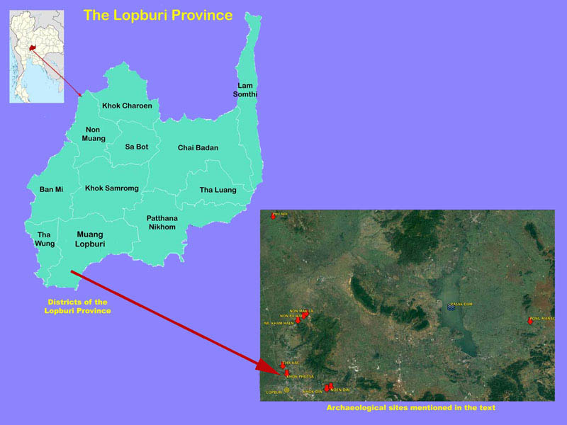
Fig. 1 – Relative position of the Khok Phutsa archaeological site.
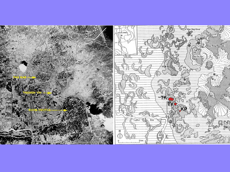
Fig. 2 – Tha Kae, Thanon Yai and Khok Phutsa in a 1945 aerial photograph and in the geomorphological map by Prof. Cremaschi.
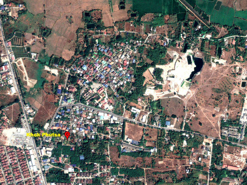
Fig. 3 – View of Khok Phutsa village, densely overgrown with modern dwellings (courtesy Google Earth).
During our first visit at Khok Phutsa in 2017, we collected abundant fragments of potshards on the surface, referable to the Neolithic period (about 2000-1100 BC), Iron Age (ca. 500 BCE-500 CE), Dvaravati period (6th-11th centuries), up to the Ayutthaya period (14th-17th centuries).
Based on this evidence, in 2018-2019 we conducted stratigraphic excavations in two test trenches (Operation 1: 5×5 m and Op. 2: 3×4 m), which provided data of considerable scientific interest. Although the archaeological deposit is relatively shallow (1.8 m at maximum depth) it comprises three rather compact cultural horizons, with a substantially similar stratigraphic sequence in Op.1 and Op.2 (Fig. 4).

Fig. 4 – Plan of the site still free from modern dwellings showing the 2019 excavation trenches.
The lowermost Layer 1, developed on the caliche bedrock, has returned seven Neolithic burials, of single individuals in poor state of conservation (B.2; B.5; B.7 in Op. 1; B.3, B.4, B.6 in Op.2).
Despite having been disturbed by subsequent anthropic activities, these burials revealed a close commonality with the burial practices documented in contemporary cemeteries of the Lopburi plain: e.g. the tendency to arrange the burials either aligned or grouped, the ritual deposition of a mussel valve on the body adorned with strings of discoid or cylindrical shell beads, the variable number of ceramic vessels placed near and on the body of the buried (Fig.s 5-6).

Fig. 5 – Op. 2. View of the Neolithic burials n. 3 and 4 under excavation.
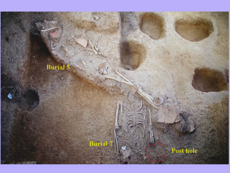
Fig. 6 – Op.1. The Neolithic B.5 cut by B.7, in turn disturbed by later anthropic activities.
Pending the AMS dating of charcoal and shell samples in progress, we have attributed Layer 1 to the Neolithic period (2000-1100 BC) on the basis of very diagnostic vascular types found in the burials and of equally diagnostic decorated potshards collected on the surface of areas not excavated. In particular:
- Necked jar with “Incised&Impressed” meanders motifs on gritty red-orange ware;
- Pedestalled bowls in chaff tempered, yellow-buff ware, covered with TRBS on the interior and on the rim contrasting with simple red painted motifs on the yellow-buff ground.
- Shallow pedestalled bowls in yellow-buff ware tempered with rice chaff, decorated with comb-scratched meanders on Thick Red Burnished Slip (TRBS) (Fig.s 7-8);
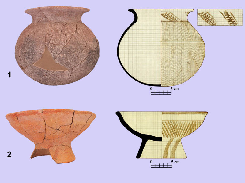
Fig. 7 – Op.1: (1) B.5, necked jar with “Incised&Impressed” motifs; (2) B.2, pedestalled bowl with Thick Red Burnished Slip (TRBS) and red painted motifs.
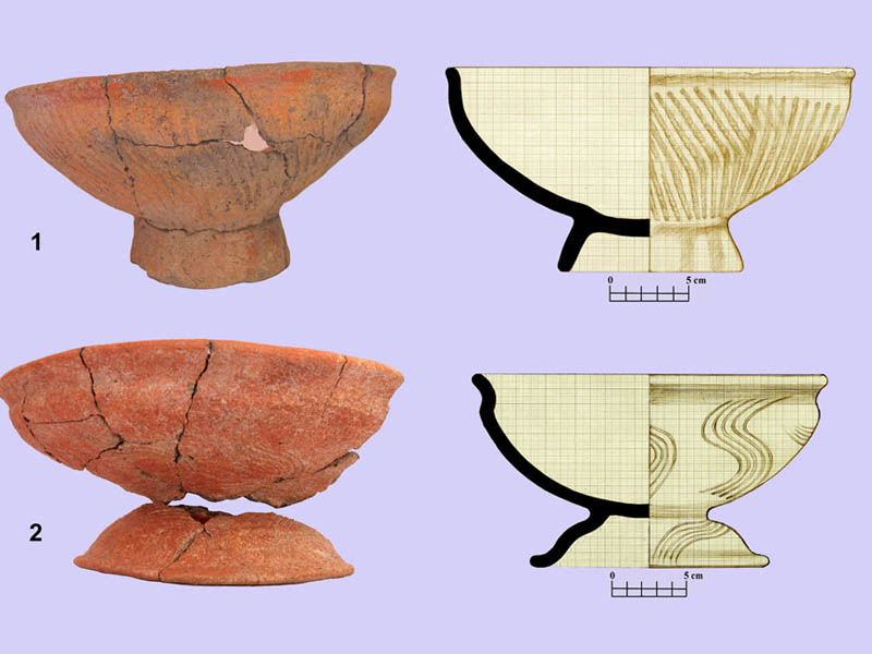
Fig. 8 – Op.2: B.4, (1) pedestalled bowl with TRBS and red painted motifs; (2) pedestalled bowl decorated with comb-scratched meanders on TRBS.
Layer 2
In both Op.1 and Op. 2 this layer consists of a clayey brown soil divided into an upper (layer 2a) and a lower horizon (layer 2b) (Fig. 9-10).
Small pits and post-holes, likely evidence of a habitation level, cut the dark-brown clayey soil containing sparse clusters of potshards and fragmentary artefacts (terracotta pellets, ear-studs, skin rubbers, pottery anvils) of protohistoric period.

Fig. 9 – Op.1. Mr Soratach Rotchanarat digging Level 2 assisted by one of our workers.
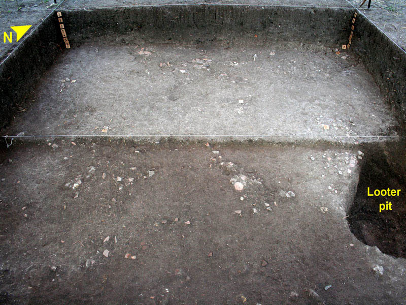
Fig. 10 – Op.1. Level 2a-Level 2b transition: note the clusters of potshards pertaining to burial jars destroyed by later anthropic activities.
We referred the entire Layer 2, including few jar burials (e.g. Stratigraphic Units-SU 25-26), which survived in a very bad state of conservation, to the transition from the Proto-Dvaravati to the early Dvaravati period, over a period of time between the 3rd/4th century and 6th century CE (Fig. 11).
Rather surprising in Op.1 are the evident episodes of conscious destruction of the Neolithic burials by a more recent community (proto-Dvaravati/Dvaravati) (Fig. 12).
Besides intentional destruction, the deep disturbances of the Neolithic burials were also due to building activities carried out in the proto-Dvaravati/Dvaravati period, as evidenced by different generations of post holes related to dwelling structures on stilts (Fig. 13).
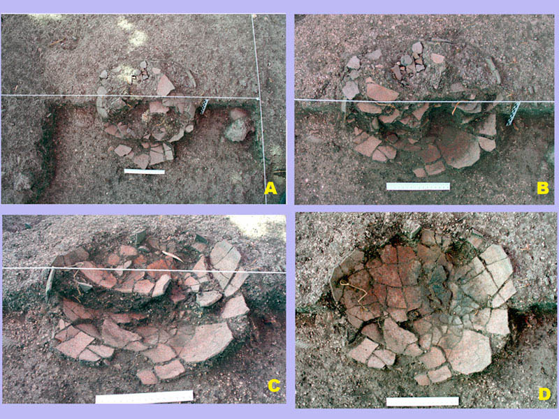
Fig. 11 – Op.1. Phases of excavation of the burial jar SU25.
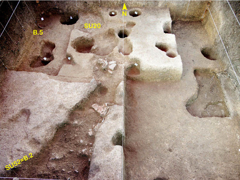
Fig. 12 – Op.1. Neolithic Burial 2 and 5 and SU 20 evidence episodes of conscious anthropic destruction.
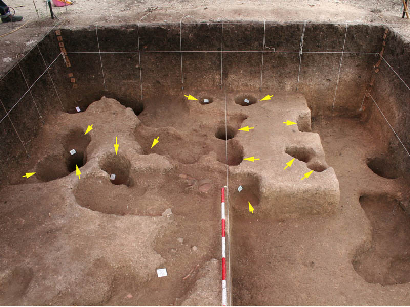
Fig. 13 – Op.1. Proto-Dvaravati-Dvaravati Period layer: evidence of different generations of post holes.
Remarkable, in layers 2 and 3, are the processing waste, blanks and semi-finished products of Tridacna shell, which testify to the local manufacture of personal ornaments. These findings, identical to those discovered at Tha Kae, demonstrate that the manufacture of shell ornaments was a specialized production at the regional level, reasonably aimed at interregional exchange (Fig. 14).
Several diagnostic artefacts associated to this layer sustain the date in the proto-Dvaravati/Dvaravati transition. In particular, the globular, cord marked jars with flaring rim used as burial containers, the terracotta ear-studs (‘dish-on-stand’ and reel types), the terracotta skin-rubbers, the small bronze ‘elongated’ bells and the fragments of tiny bronze bangles.
All these artefacts have close comparisons to types found in late Iron Age sites in Central and Northeast Thailand (Fig. 15).
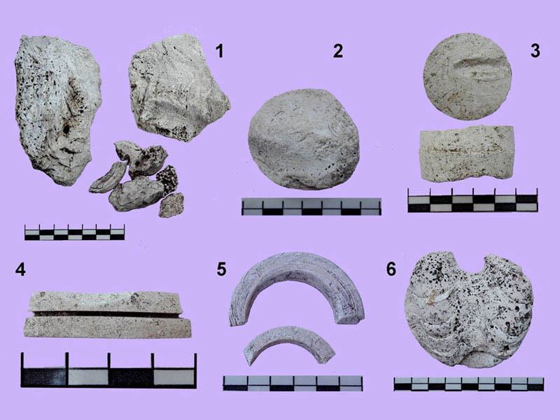
Fig. 14 – Production waste of Tridacna shell jewelry.

Fig. 15 – The day’s finds are washed, dried, recorded and arranged for packing.
Layer 3
Very disturbed by anthropic and natural agents, this dark-brown, clayey layer returned fragments of Chinese celadon (16th-17th cent.) (Fig. 16a) and “blue-and-white” export porcelains (17th-19th cent.) (Fig. 16d), Thai Sangkhalok glazed stonewares (13th-18th cent.) (Fig. 16 b-c), Ayutthaya earthenwares with stamped motifs (1351-1767), and late Thai dark-glazed jars (17th-19th cent. and later) (Fig 16e).
These artefacts were associated to Neolithic residual finds (e.g. small stone adzes, and “Incised&Impressed” potsherds) from the lower deposit disturbances.
The arrangement of the Neolithic tombs excavated in Op.1 and Op.2 indicates that further information could be obtained in the western half of the site, where, also judging by the type of ceramic fragments found on the surface, an extension of the Neolithic cemetery is suspected.
However, for the moment, the available data are sufficiently informative for the study of that small Neolithic community, hitherto undocumented by previous investigations, which, like other Neolithic communities in the region, settled on one of the many terraces formed by the ancient Paleo-riverbed system.
The material culture and funerary rituals of these communities, as documented at several contemporary sites of the Lopburi region, characterize what we call the “Neolithic facies” of the Lopburi Plain.
A second point of interest directly invests the knowledge of an agricultural community at the transition from the proto-Dvaravati to the Dvaravati period. It is now becoming clear that in the mid-to-late Iron Age the inhabitants of the Lopburi Plain began not to recognize any link of continuity or descent with the oldest local communities. This is evidenced by pit graves that destroyed previous burials with no respect for older human remains (Fig. 17).

Fig. 16 – Fragments of Chinese and Thai glazed wares.
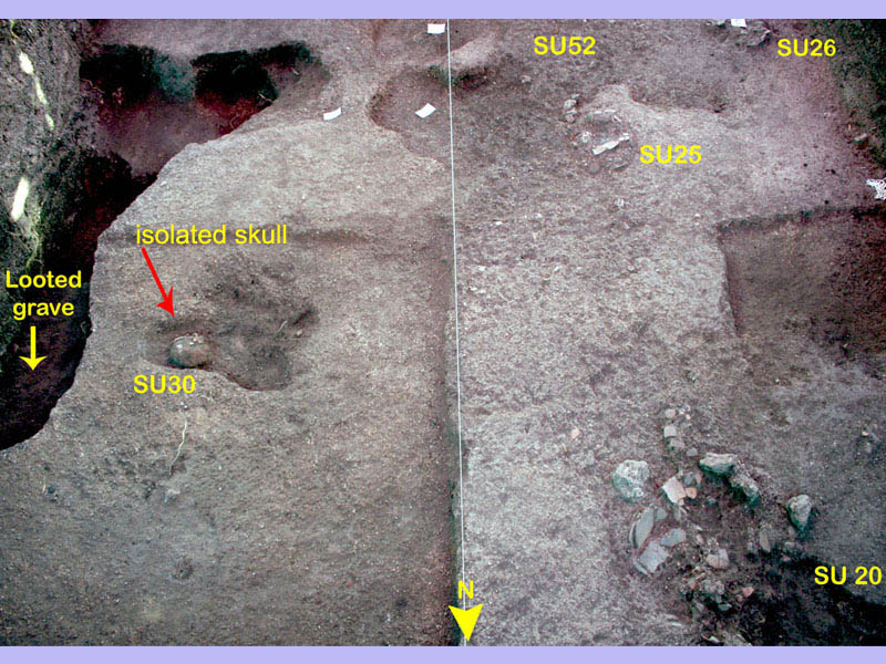
Fig. 17 – Op.1. SU20 –Neolithic pots crushed by large stones in a pit; SU52 – disturbed Neolithic burial; SU26 – broken burial jar.
Did this phenomenon, observed at Khok Phutsa, Non Pa Wai and Tha Kae, derives from the loss of knowledge of the old lines of descent, or does it derive from the arrival of new settlers? In this case, were the newcomers the Mon people who would have given life to the Dvaravati civilization?
Looking for an answer to these questions leads us to focus on a new research line of investigation on the prehistoric roots of the Dvaravati civilization in the Lopburi and Pasak river basins (Fig.s 18-19).
Fig. 18 – Prof. Thanik Lertcharnrit (FoA – Silpakorn Univ.), excavator of the moated site of Promtin Tai (Lopburi prov.), visits our excavation.

Fig. 19 – Three archaeologists looking at an artifact-free level … archeology can be boring at times.